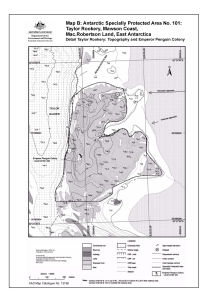
Map 13166: Taylor Rookery, Mawson Coast. Map B : Antarctic Specially Protected Area No. 101. Detail Taylor Rookery : topography and emperor penguin colony
Map details
| Map Number | 13166 |
| Title | Taylor Rookery, Mawson Coast. Map B : Antarctic Specially Protected Area No. 101. Detail Taylor Rookery : topography and emperor penguin colony |
| Edition | 1 (Out of Date) |
| Next Edition | [Next Edition : 2] |
| Scale | 1 : 5000 |
| Publication date | May 2005 |
| Publisher |
Australian Antarctic Division (Australia)
|
| Spatial coverage |
( 60.8750° -67.4494°)
,
( 60.8958° -67.4494°)
,
( 60.8958° -67.4589°)
( 60.8750° -67.4589°) |
| Projection | Universal Transverse Mercator |
| Physical size | - |
| Notes | This map was created in ArcMap but the map content is an image. |
| Keywords | Antarctic Specially Protected Area No. 101 , ASPA No. 101 , Taylor Rookery , Emperor Penguin Colony |
Downloads
This is a digital map available for downloading.
Map Lists
No maps lists available.
Additional Information
| Horizontal datum | WGS84 |
Preview