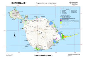
Map 13224: Heard Island: Proposed Ramsar wetland areas
Map details
| Map Number | 13224 |
| Title | Heard Island: Proposed Ramsar wetland areas |
| Edition | 2 |
| Previous edition | [Previous edition : 1] |
| Scale | 1 : 120 000 |
| Publication date | January 2006 |
| Publisher |
Australian Antarctic Division (Australia)
|
| Spatial coverage |
( 73.2500° -52.9500°)
,
( 73.8667° -52.9500°)
,
( 73.8667° -53.2000°)
( 73.2500° -53.2000°) |
| Projection | Universal Transverse Mercator |
| Physical size | 29.7 x 42 cm A3 |
| Notes |
The wetland areas were compiled by Dr Jenny Scott using 1987 aerial photography, 1988 and 1991 SPOT satellite imagery and 2003 Quickbird satellite imagery.
These areas are approximate only due to the dynamic nature of the Heard Island environment, particularly areas affected by glacial retreat and coastal erosion. This edition was produced to include fauna data collected by Dr Eric Woehler during the Australian Antarctic Division's 2003/04 expedition to Heard island. Map produced for the Heard and McDonald Islands Marine Reserve Management Plan 2005. |
| Keywords | wetlands , Laurens Peninsula , Azorella Peninsula , Spit Point |
Downloads
This is a digital map available for downloading.
Map Lists
This map belongs to the following lists. Use the link on the list to see all maps belonging to that list
Additional Information
| Horizontal datum | WGS84 |
| Vertical datum | Mean sea level |
| Nomenclature | Australian Antarctic Gazetteer |
Preview