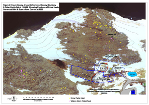
Map 13383: Casey quarry area with surveyed quarry boundary and outer limits set at 1985/86 showing positions of petrel nests current at 2004 and quarry face current at 2000
Map details
| Map Number | 13383 |
| Title | Casey quarry area with surveyed quarry boundary and outer limits set at 1985/86 showing positions of petrel nests current at 2004 and quarry face current at 2000 |
| Edition | 1 |
| Scale | 1 : c1666 |
| Publication date | June 2005 |
| Publisher |
Australian Antarctic Division (Australia)
|
| Spatial coverage |
(110.5133° -66.2792°)
,
(110.5239° -66.2792°)
,
(110.5239° -66.2986°)
(110.5133° -66.2986°) |
| Projection | Universal Transverse Mercator |
| Physical size | 21 x 29.7 cm A4 |
| Notes |
This map is included in the Casey Quarry Environmental Management Statement published by the Operations Branch, Australian Antarctic Division in July 2005. The map was produced by Brett Gogoll with assistance from the Australian Antarctic Data Centre. |
| Reference | C/05/03 Sheet 1 |
| Keywords | Casey Quarry , Snow Petrel Nest , Wilson Storm Petrel Nest , Reeve Hill , C/0 5/03-01.Dwg. |
Downloads
This is a digital map available for downloading.
Map Lists
This map belongs to the following lists. Use the link on the list to see all maps belonging to that list
Additional Information
Preview