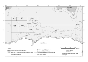
Map 13435: Australia to Antarctica: administrative boundaries and physical features
Map details
| Map Number | 13435 |
| Title | Australia to Antarctica: administrative boundaries and physical features |
| Edition | 1 |
| Scale | 1 : 31 000 000 |
| Publication date | November 2007 |
| Publisher | - |
| Spatial coverage |
( 20.0000° -30.0000°)
,
(160.0000° -30.0000°)
,
(160.0000° -80.0000°)
( 20.0000° -80.0000°) |
| Projection | Mercator |
| Physical size | - |
| Notes |
The map was produced at the request of Dr Steve Nicol, Australian Antarctic Division. The antarctic coastline data is from the Antarctic Digital Database version 4.0 © Scientific Committee on Antarctic Research 1993-2003. The bathymetric data is from "Centenary Edition of the GEBCO Digital Atlas", 2003, published on behalf of the Intergovernmental Oceanographic Commission and the International Hydrographic Organization as part of the General Bathymetric Chart of the Oceans; British Oceanographic Data Centre, Liverpool. The outer limits of Australian EEZs and Australian Continental Shelves are from 'Australian Maritime Boundaries' published by Geoscience Australia in 2006. Australia has not entered into any delimitation arrangements with other countries in relation to maritime areas adjacent to the Australian Antarctic Territory (AAT). For the purposes of this map the maritime boundaries adjacent to the AAT have been drawn back to the point of equidistance even though Australia has valid claims beyond that point. The use of equidistant lines is without prejudice to future delimitation arrangements. The maximum extent of sea ice data was provided by Dr Tony Worby (AAD) and is based on passive microwave data between 1989 and 1999. |
| Keywords | CCAMLR Statistical Reporting Area , Australian Exclusive Economic Zone , Ice Extent , Australian Continental Shelf |
Downloads
This is a digital map available for downloading.
Map Lists
This map belongs to the following lists. Use the link on the list to see all maps belonging to that list
Additional Information
| Horizontal datum | WGS84 |
Preview