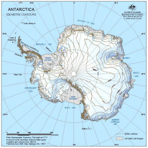
Map 13641: Antarctica : 500 metre contours
Map details
| Map Number | 13641 |
| Title | Antarctica : 500 metre contours |
| Edition | 2 |
| Previous edition | [Previous edition : 1] |
| Scale | 1 : 45 000 000 |
| Publication date | June 2009 |
| Publisher | - |
| Spatial coverage |
(-180.0000° -40.0000°)
,
(180.0000° -40.0000°)
,
(180.0000° -90.0000°)
(-180.0000° -90.0000°) |
| Projection | Polar Stereographic |
| Physical size | 29.7 x 21 cm A4 |
| Keywords | 500 Metre Contours , Topographic |
Downloads
This is a digital map available for downloading.
Map Lists
This map belongs to the following lists. Use the link on the list to see all maps belonging to that list
Additional Information
| Horizontal datum | WGS84 |
Preview