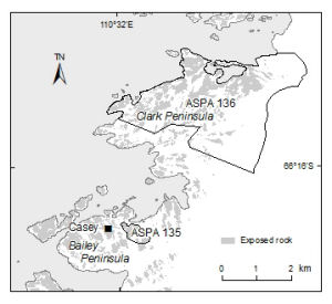
Map 13736: Clark and Bailey Peninsulas, Windmill Islands [Black and white]
Map details
| Map Number | 13736 |
| Title | Clark and Bailey Peninsulas, Windmill Islands [Black and white] |
| Edition | - |
| Scale | 1 : 100 000 |
| Publication date | November 2009 |
| Publisher |
Australian Antarctic Division (Australia)
|
| Spatial coverage |
(110.4653° -66.2269°)
,
(110.6622° -66.2269°)
,
(110.6622° -66.2986°)
(110.4653° -66.2986°) |
| Projection | Universal Transverse Mercator |
| Physical size | 8 x 8.9 cm |
| Notes | The map includes Antarctic Specially Protected Areas 135 and 136. |
| Keywords | - |
Downloads
This is a digital map available for downloading.
Map Lists
This map belongs to the following lists. Use the link on the list to see all maps belonging to that list
Additional Information
| Horizontal datum | WGS84 |
Preview