Map 13741: Voyage 4 1995/96 (BROKE) and Voyage 3 2005/06 (BROKE-West)
Map details
| Map Number | 13741 |
| Title | Voyage 4 1995/96 (BROKE) and Voyage 3 2005/06 (BROKE-West) |
| Edition | 1 |
| Scale | 1 : 27 000 000 |
| Publication date | February 2010 |
| Publisher |
Australian Antarctic Division (Australia)
|
| Spatial coverage |
( 26.9667° -41.5667°)
,
(161.2000° -41.5667°)
,
(161.2000° -72.7667°)
( 26.9667° -72.7667°) |
| Projection | Mercator |
| Physical size | 12.9 x 27.9 cm |
| Notes |
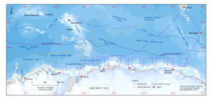
This map shows the tracks of two voyages of the Australian Antarctic Program: Voyage 4 1995/96 (BROKE) and Voyage 3 2005/06 (BROKE-West). The coastline of Antarctica is from the Antarctic Digital Database version 5 © Scientific Committee on Antarctic Research 1993-2006. The bathymetry is from "Centenary Edition of the GEBCO Digital Atlas", 2003, published on behalf of the Intergovernmental Oceanographic Commission and the International Hydrographic Organization as part of the General Bathymetric Chart of the Oceans; British Oceanographic Data Centre, Liverpool. The polar front is from Alejandro H. Orsi, Thomas Whitworth III, and Worth D. Nowlin Jr (1995) On the meridional extent and fronts of the Antarctic Circumpolar Current. Deep-Sea Research 42 (5), 641-673. The maximum sea ice extent is the mean seasonal data described by the metadata record 'The maximum extent of sea ice in the southern hemisphere by day and by winter season' with Entry ID: sea_ice_extent_winter. The map is to be included in a chapter written by Dr Steve Nicol (Australian Antarctic Division) for a book. The chapter is titled 'Pelagic ecosystems in the waters off East Antarctica (30E to 150E). |
| Keywords | Australian Antarctic Program , Voyage Tracks , Brokewest , Broke West , Ship Tracks |
Downloads
This is a digital map available for downloading.
Map Lists
This map belongs to the following lists. Use the link on the list to see all maps belonging to that list
Additional Information
Preview