Map 14004: Australia's Maritime Jurisdiction around the State of Tasmania
Map details
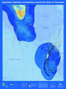
| Map Number | 14004 |
| Title | Australia's Maritime Jurisdiction around the State of Tasmania |
| Edition | 1 |
| Scale | 1 : 2 300 000 |
| Publication date | 2010 |
| Publisher |
Geoscience Australia (Australia)
|
| Spatial coverage |
(138.0000° -39.0000°)
,
(166.0000° -39.0000°)
,
(166.0000° -61.0000°)
(138.0000° -61.0000°) |
| Projection | Mercator |
| Physical size | 113 x 84 cm |
| Reference | GeoCat 70315 |
| Keywords | Australia's Territorial Sea , Australia's Contiguous Zone Limit , Australia's Exclusive Economic Zone Limit , Geocat 70315 , Continental Shelf Treaty Boundary , Hjort Trench , Emerald Basin , TASMAn ESCARpment , TASMAn Basin , Ruysegur Trough , Solander Trough |
Downloads
This is a digital map available for downloading.
Map Lists
This map belongs to the following lists. Use the link on the list to see all maps belonging to that list
Additional Information
| Horizontal datum | WGS84 |
| Nomenclature | Australian Antarctic Gazetteer |
Preview