Map 14013: Cape Denison Historic Site
Mawson Centennial 1911-2011, Commonwealth Bay
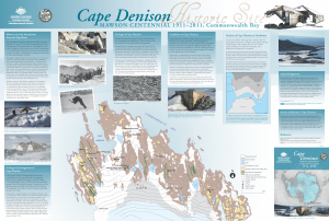
Map details
| Map Number | 14013 |
| Title | Cape Denison Historic Site Mawson Centennial 1911-2011, Commonwealth Bay |
| Edition | 1 |
| Scale | 1 : 3330 |
| Publication date | 2011 |
| Publisher |
Geoscience Australia (Australia)
|
| Spatial coverage |
(142.6500° -66.9861°)
,
(142.6917° -66.9861°)
,
(142.6917° -66.9972°)
(142.6500° -66.9972°) |
| Projection | Universal Transverse Mercator |
| Physical size | 63 x 93 cm |
| Notes |
This map was developed by Geoscience Australia in collaboration with the Australian Antarctic Division, in commemoration of the centenary of Sir Douglas Mawson's Australasian Antarctic Expedition. Includes notes on the history and geology of Cape Denison, photos and map showing the position of Cape Denison in Gondwana. Includes references. |
| Reference | Geocat ref. 72710 |
| Keywords | Cape Denison , Mawson Centennial 1911-2011 , Boat Harbour , John O'groats , Petrel Hill , Land's End , Penguin Knob , Azimuth Hill , Memorial Hill , Beryl Hill , Geocat Ref. 72710 |
Downloads
Map Lists
This map belongs to the following lists. Use the link on the list to see all maps belonging to that list
Additional Information
| Nomenclature | Australian Antarctic Gazetteer |
Preview