Map 14050: Australasian Antarctic Expedition illustrating sledging operations from the Western Base Station
Map details
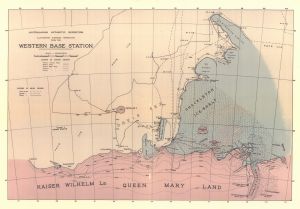
| Map Number | 14050 |
| Title | Australasian Antarctic Expedition illustrating sledging operations from the Western Base Station |
| Edition | 1 |
| Scale | 1 : c1 330 000 |
| Publication date | - |
| Publisher |
Australia
|
| Spatial coverage |
( 87.5000° -63.5000°)
,
(100.5000° -63.5000°)
,
(101.5000° -67.5000°)
( 86.5000° -67.5000°) |
| Projection | - |
| Physical size | 50.4 x 33.7 cm |
| Keywords | Kaiser Wilhelm Land , Queen Mary Land , Davis Sea , Shackleton Ice Shelf , Gauss Winter Station , Posadowsky Bay , Cape Filcher , Helen Glacier , Western Barrier , Denman Glacier , Western Coastal Party , Eastern Party , Eastern Depot Party , Southern Depot Party , Western Depot Party , ship , sledge , tracks , historical , AAE |
Downloads
This is a hard copy map that has been scanned. See information about obtaining copies of hard copy maps.
- A LZW compressed TIFF
- A print file (PDF)
- National Library of Australia Bib ID 4980815 (External site)
- A Georeferenced TIFF
Map Lists
No maps lists available.
Additional Information
Preview