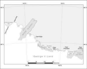
Map 14124: Cape Denison to Cook Ice Shelf [Black and white]
Map details
| Map Number | 14124 |
| Title | Cape Denison to Cook Ice Shelf [Black and white] |
| Edition | 1 |
| Scale | 1 : 3 500 000 |
| Publication date | July 2012 |
| Publisher |
Australian Antarctic Division (Australia)
|
| Spatial coverage |
(142.3728° -65.9556°)
,
(153.5523° -65.9556°)
,
(153.5523° -69.1967°)
(142.3728° -69.1967°) |
| Projection | Polar Stereographic |
| Physical size | 12 x 15 cm |
| Keywords | Cape Gray , Mertz Glacier , Cape Bage , Ninnis Glacier , Buckley Bay , Cape Wild , Cape Freshfield , Krichak Bay , Cape Dmitriev , Cook Ice Shelf |
Downloads
This is a digital map available for downloading.
Map Lists
This map belongs to the following lists. Use the link on the list to see all maps belonging to that list
Additional Information
| Nomenclature | Australian Antarctic Gazetteer |
Preview