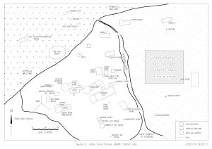
Map 14173: Atlas Cove former ANARE Station site
Map details
| Map Number | 14173 |
| Title | Atlas Cove former ANARE Station site |
| Edition | 1 |
| Scale | 1 : 570 |
| Publication date | September 1995 |
| Publisher |
Australian Antarctic Division (Australia)
|
| Spatial coverage |
( 73.3903° -53.0161°)
,
( 73.3989° -53.0161°)
,
( 73.3989° -53.0200°)
( 73.3903° -53.0200°) |
| Projection | Not Given |
| Physical size | - |
| Reference | 2/92/10 Sheet 2 |
| Keywords | Atlas Cove , Anare Station Heritage Area |
Downloads
This is a digital map available for downloading.
Map Lists
This map belongs to the following lists. Use the link on the list to see all maps belonging to that list
Additional Information
| Nomenclature | Australian Antarctic Gazetteer |
Preview