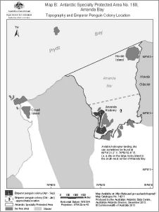
Map 14211: Map B: Antarctic Specially Protected Area No. 169 , Amanda Bay
Topography and Emperor Penguin Colony Location
Map details
| Map Number | 14211 |
| Title | Map B: Antarctic Specially Protected Area No. 169 , Amanda Bay Topography and Emperor Penguin Colony Location |
| Edition | 2 |
| Previous edition | [Previous edition : 1] |
| Scale | 1 : 70 000 |
| Publication date | December 2013 |
| Publisher |
Australian Antarctic Division (Australia)
|
| Spatial coverage |
( 76.6722° -69.2128°)
,
( 76.9164° -69.2128°)
,
( 76.9164° -69.3122°)
( 76.6722° -69.3122°) |
| Projection | Universal Transverse Mercator |
| Physical size | 20 x 15 cm A4 |
| Notes | This map was produced for the management plan for Antarctic Specially Protected Area No. 169, 2014. |
| Keywords | - |
Downloads
This is a digital map available for downloading.
Map Lists
This map belongs to the following lists. Use the link on the list to see all maps belonging to that list
Additional Information
| Horizontal datum | WGS84 |
| Nomenclature | Australian Antarctic Gazetteer |
Preview