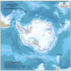
Map 14245: Antarctica and the Southern Ocean
Map details
| Map Number | 14245 |
| Title | Antarctica and the Southern Ocean |
| Edition | 2 |
| Previous edition | [Previous edition : 1] |
| Scale | 1 : 45 000 000 |
| Publication date | August 2013 |
| Publisher | - |
| Spatial coverage |
(-180.0000° -50.0000°)
,
(180.0000° -50.0000°)
,
(180.0000° -90.0000°)
(-180.0000° -90.0000°) |
| Projection | Polar Stereographic |
| Physical size | 19.7 x 19.5 cm |
| Notes |
Information about data used in this map can be obtained by searching using the following Dataset ids: Bathymetry: Dataset 186 (Qinfos 534, 535, 537 to 540) Antarctica: Antarctic Digital Database version 4 The sea ice extent data was obtained from the NSIDC. |
| Keywords | Antarctic Polar Front , Maximum And Minimum Sea Ice Extent , Bathymetry , Topographic |
Downloads
This is a digital map available for downloading.
Map Lists
This map belongs to the following lists. Use the link on the list to see all maps belonging to that list
Additional Information
Preview