Map 14286: Heard Island and McDonald Islands Marine Reserve
Amendment to boundary
Map details
| Map Number | 14286 |
| Title | Heard Island and McDonald Islands Marine Reserve Amendment to boundary |
| Edition | 1 |
| Scale | 1 : 3 380 000 |
| Publication date | April 2014 |
| Publisher |
Australian Antarctic Division (Australia)
|
| Spatial coverage |
( 70.5789° -49.7583°)
,
( 79.1164° -49.7583°)
,
( 79.1164° -53.6439°)
( 70.5789° -53.6439°) |
| Projection | Gnomonic |
| Physical size | 14.3 x 19 cm |
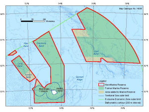
| Notes |
The map shows the Heard Island and McDonald Islands Marine Reserve boundary that came into effect in March 2014 together with (i) the area occupied by the reserve before the March 2014 proclamation, and (ii) the area that the proclamation added to the reserve. The bathymetric contours were derived from the bathymetric grid described by the Geoscience Australia metadata record 'Kerguelen Plateau Bathymetric Grid 2010'. This map was produced for the Australian Antarctic Magazine. Map 14221 is a similar map at A4 size. |
| Keywords | Coral , Aurora , Discovery , Shell , Pike , Gunnari |
Downloads
This is a digital map available for downloading.
Map Lists
This map belongs to the following lists. Use the link on the list to see all maps belonging to that list
Additional Information
| Horizontal datum | WGS84 |
Preview