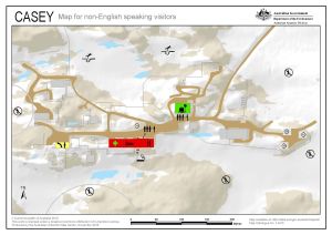
Map 14479: Casey: Critical safety map for non-English speaking visitors
Map details
| Map Number | 14479 |
| Title | Casey: Critical safety map for non-English speaking visitors |
| Edition | 1 |
| Scale | 1 : c2200 |
| Publication date | 24 November 2015 |
| Publisher |
Australian Antarctic Division (Australia)
|
| Spatial coverage |
(110.5214° -66.2803°)
,
(110.5350° -66.2803°)
,
(110.5350° -66.2839°)
(110.5214° -66.2839°) |
| Projection | Universal Transverse Mercator |
| Physical size | 21 x 29.7 cm A4 |
| Notes | This map has been developed to supplement information that has been translated into multiple languages to implement the AAD’s ‘Communicating with non-English speaking background workers policy'. |
| Keywords | - |
Downloads
This is a digital map available for downloading.
Map Lists
This map belongs to the following lists. Use the link on the list to see all maps belonging to that list
Additional Information
| Horizontal datum | WGS84 |
| Vertical datum | Mean sea level |
Preview