Map 14506: McDonald Islands Satellite Image Map
Map details
| Map Number | 14506 |
| Title | McDonald Islands Satellite Image Map |
| Edition | 1 |
| Scale | 1 : 38 000 |
| Publication date | November 2012 |
| Publisher |
Australian Antarctic Division (Australia)
|
| Spatial coverage |
( 72.5778° -53.0281°)
,
( 72.6347° -53.0281°)
,
( 72.6347° -53.0533°)
( 72.5778° -53.0533°) |
| Projection | Universal Transverse Mercator |
| Physical size | 7.5 x 10 cm |
| Notes |
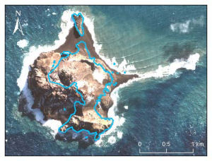
The map shows a DigitalGlobe satellite image of McDonald Island acquired 9 April 2003. Overlaid on the
image is the coastline mapped from an aerial photograph taken on 11 March 1980. Map 13159 shows the aerial photograph as an inset. |
| Keywords | Satellite Imagery |
Downloads
Map Lists
This map belongs to the following lists. Use the link on the list to see all maps belonging to that list
Additional Information
| Horizontal datum | WGS84 |
Preview