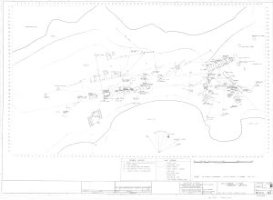
Map 14559: Macquarie Island Station Layout
Map details
| Map Number | 14559 |
| Title | Macquarie Island Station Layout |
| Edition | - |
| Scale | 1 : c200 |
| Publication date | 23 February 1970 |
| Publisher |
Department of Works, Victorian and Tasmanian Branch (Australia)
|
| Spatial coverage |
(158.9331° -54.4984°)
,
(158.9390° -54.4964°)
,
(158.9418° -54.4992°)
(158.9362° -54.5014°) |
| Projection | Not Given |
| Physical size | 91.4 x 106.3 cm |
| Notes |
Drawing No. VA70/144 Coverage shown is approximate |
| Keywords | Va70/144 |
Downloads
This is a hard copy map that has been scanned. See information about obtaining copies of hard copy maps.
Map Lists
This map belongs to the following lists. Use the link on the list to see all maps belonging to that list
Additional Information
Preview