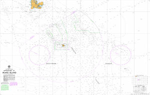
Map 14602: Aus 597 Australia - Southern Ocean - Approaches to Heard Island
Map details
| Map Number | 14602 |
| Title | Aus 597 Australia - Southern Ocean - Approaches to Heard Island |
| Edition | 2 |
| Scale | 1 : 1 500 000 |
| Publication date | 13 February 2015 |
| Publisher |
Hydrographic Service, Department of the Navy, Wollongong (Australia)
|
| Spatial coverage |
( 64.1667° -48.9011°)
,
( 86.3333° -48.9011°)
,
( 86.3333° -57.6667°)
( 64.1667° -57.6667°) |
| Projection | Mercator |
| Physical size | 73 x 110.5 cm |
| Notes | Small corrections between editions. |
| Reference | Aus 597, Aus597 |
| Keywords | Heard Island , Mcdonald Island , Southern Ocean , Aus 597 , Iles Kerguelen , Shag , Chart , Nautical |
Downloads
Map Lists
This map belongs to the following lists. Use the link on the list to see all maps belonging to that list
Additional Information
| Horizontal datum | WGS 84 |
| Vertical unit | Metres |
Preview