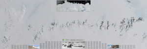
Map 14697: Fimbulheimen
Map details
| Map Number | 14697 |
| Title | Fimbulheimen |
| Edition | 1 |
| Scale | 1 : 250 000 |
| Publication date | 2017 |
| Publisher |
Norsk Polarinstitutt, Oslo (Norway)
|
| Spatial coverage |
( -4.3000° -70.5000°)
,
( 15.2000° -70.5000°)
,
( 15.2000° -73.0000°)
( -4.3000° -73.0000°) |
| Projection | Polar stereographic |
| Physical size | 87 x 260 cm |
| Notes | The product also features a place names index and a small inset satellite map for the larger area. |
| Keywords | Fimbulheimen , Satellite |
Downloads
This is a digital map available for downloading.
Map Lists
This map belongs to the following lists. Use the link on the list to see all maps belonging to that list
Additional Information
Preview