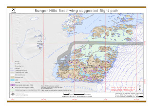
Map 15967: Bunger Hills fixed-wing suggested flight paths
Map details
| Map Number | 15967 |
| Title | Bunger Hills fixed-wing suggested flight paths |
| Edition | 1 |
| Scale | 1 : 250 000 |
| Publication date | October 2023 |
| Publisher |
Australian Antarctic Division (Australia)
|
| Spatial coverage |
(100.3589° -66.0494°)
,
(101.2789° -66.0500°)
,
(101.2800° -66.3700°)
(100.3600° -66.3700°) |
| Projection | UTM Zone 47 |
| Physical size | 29.7 x 21 cm A4 |
| Keywords | - |
Downloads
This is a digital map available for downloading.
Map Lists
This map belongs to the following lists. Use the link on the list to see all maps belonging to that list
Additional Information
| Horizontal datum | WGS84 |
| Vertical unit | Metres |
| Nomenclature | Australian Antarctic Names Gazetteer |
Preview