Map 15982: Mawson fixed-wing suggested flight paths
Map details
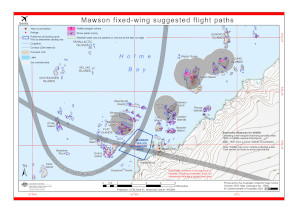
| Map Number | 15982 |
| Title | Mawson fixed-wing suggested flight paths |
| Edition | 4 |
| Previous edition | [Previous edition : 3] |
| Scale | 1 : 70 000 |
| Publication date | October 2023 |
| Publisher |
Australian Antarctic Division (Australia)
|
| Spatial coverage |
( 62.6444° -67.5258°)
,
( 63.0683° -67.5258°)
,
( 63.0683° -67.6219°)
( 62.6444° -67.6219°) |
| Projection | Universal Transverse Mercator |
| Physical size | 21 x 29.7 cm A4 |
| Keywords | Azimuth Island , Parallactic Islands , Arrow Island , Marble Rock , Van Hulssen Islands , Kellas Islands , Flat Islands , Stinear Island , Bechervaise Island , Evans Island , Kerry Island , Departure Rocks , Lee Island , Teyssier Island , Petersen Island , Verner Island , Jocelyn Islands , Welch Island , Klung Islands , Skiway , Canopus Islands |
Downloads
This is a digital map available for downloading.
Map Lists
This map belongs to the following lists. Use the link on the list to see all maps belonging to that list
Additional Information
| Horizontal datum | WGS84 |
| Vertical datum | Mean Sea Level |
| Nomenclature | Australian Antarctic Gazetteer |
Preview