Map 15991: Denman Terrestrial Campaign - Bunger Hills (Topographic)
Map details
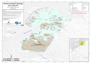
| Map Number | 15991 |
| Title | Denman Terrestrial Campaign - Bunger Hills (Topographic) |
| Edition | 1 |
| Scale | 1 : 200 000 |
| Publication date | August 2023 |
| Publisher |
Australian Antarctic Division (Australia)
|
| Spatial coverage |
(100.0879° -65.9062°)
,
(101.8228° -65.9062°)
,
(101.8228° -66.4254°)
(100.0879° -66.4254°) |
| Projection | UTM 47S |
| Physical size | 29.7 x 42 cm A3 |
| Notes |
Map 2 of 4 topographical maps to support the Denman Terrestrial Campaign. Other maps in the series: 15994 - Map 1 - Overview map 15992 - Map 3 - Obruchev Hills 15993 - Map 4 - Mt Strathcona |
| Keywords | - |
Downloads
This is a digital map available for downloading.
Map Lists
This map belongs to the following lists. Use the link on the list to see all maps belonging to that list
Additional Information
| Horizontal datum | WGS84 |
| Vertical unit | Metres |
Preview