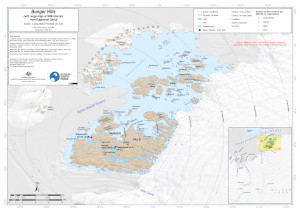
Map 16154: Bunger Hills with range rings at 5NM from Edgeworth David (Topographic)
Map details
| Map Number | 16154 |
| Title | Bunger Hills with range rings at 5NM from Edgeworth David (Topographic) |
| Edition | 1 |
| Scale | 1 : 200 000 |
| Publication date | August 2023 |
| Publisher |
Australian Antarctic Division (Australia)
|
| Spatial coverage |
(100.0862° -65.9054°)
,
(101.8211° -65.9054°)
,
(101.8211° -66.4245°)
(100.0862° -66.4245°) |
| Projection | UTM 47S |
| Physical size | 29.7 x 42 cm A3 |
| Notes | Topographic map of Bunger Hills area at 1:200k with range rings showing distance from Edgeworth David in nautical miles at 5NM intervals. |
| Keywords | Denman Terrestrial Campaign , |
Downloads
This is a digital map available for downloading.
Map Lists
This map belongs to the following lists. Use the link on the list to see all maps belonging to that list
Additional Information
| Horizontal datum | WGS84 |
| Vertical unit | Metres |
Preview