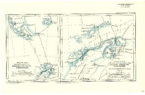
Map 3682: Sketch Map to illustrate the Exploration of the Swedish Antarctic Expedition 1902-3
Map details
| Map Number | 3682 |
| Title | Sketch Map to illustrate the Exploration of the Swedish Antarctic Expedition 1902-3 |
| Edition | 1 |
| Scale | 1 : 3 000 000 |
| Publication date | 1904 |
| Publisher |
Royal Geographical Society (United Kingdom)
|
| Spatial coverage |
( -65.5000° -61.3333°)
,
( -54.0000° -61.3333°)
,
( -54.0000° -66.0000°)
( -65.5000° -66.0000°) |
| Projection | - |
| Physical size | 24.5 x 38.7 cm |
| Notes | By O. Nordenskiold and S.A. Duse 1902-3. Secant conical projection. 2 sketch maps on the one sheet. Left map "Sketch map showing the track of the Swedish Antarctic Expedition". Right map "Sketch map to illustrate the Exploration of the Swedish Antarctic Expedition" Extents for this map entry are for the right map. |
| Reference | 889 |
| Keywords | Swedish Antarctic Expedition 1902-3 , O. Nordenskiold , S.A. Duse , King OSCAR Ii Land , Danco Land , Ship Tracks , Historical |
Downloads
No downloads available.
Map Lists
This map belongs to the following lists. Use the link on the list to see all maps belonging to that list
Additional Information
Preview