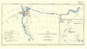
Map 3685: Map showing the Work of the National Antarctic Expedition 1902-3-4
Map details
| Map Number | 3685 |
| Title | Map showing the Work of the National Antarctic Expedition 1902-3-4 |
| Edition | - |
| Scale | 1 : 2 500 000 |
| Publication date | 1904 |
| Publisher |
Royal Geographical Society (United Kingdom)
|
| Spatial coverage |
(132.0000° -75.1667°)
,
(-150.0000° -75.1667°)
,
(-150.0000° -84.0000°)
(132.0000° -84.0000°) |
| Projection | - |
| Physical size | 38 x 70 cm |
| Notes | From a drawing by Lieut. George F.A. Mulock, R.N. Secant conical projection. Inset map showing the track of the "Discovery" from New Zealand. (1:40,000,000) |
| Reference | 891 |
| Keywords | National Antarctic Expedition 1902-3-4 , George F.A. Mulock , Ship Tracks , Historical |
Downloads
No downloads available.
This is a hard copy map. See information about obtaining copies of hard copy maps.
Map Lists
This map belongs to the following lists. Use the link on the list to see all maps belonging to that list
Additional Information
Preview