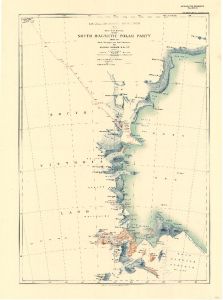
Map 3690: British Antarctic Expedition 1907 : Route and Surveys of the South Magnetic Polar Party 1908-09
Map details
| Map Number | 3690 |
| Title | British Antarctic Expedition 1907 : Route and Surveys of the South Magnetic Polar Party 1908-09 |
| Edition | - |
| Scale | 1 : 1 500 000 |
| Publication date | 1909 |
| Publisher | - |
| Spatial coverage |
(151.0000° -72.3333°)
,
(173.0000° -72.3333°)
,
(173.0000° -78.7500°)
(151.0000° -78.7500°) |
| Projection | Not Given |
| Physical size | 53.5 x 40 cm |
| Notes | From triangulation and traverses by Douglas Mawson B.Sc., B.E. Also described at http://www.loc.gov/item/2002624043/ |
| Reference | 976 |
| Keywords | British Antarctic Expedition 1908-09 , South Magnetic Polar Party , Douglas Mawson , Survey Marks , Historical |
Downloads
No downloads available.
Map Lists
This map belongs to the following lists. Use the link on the list to see all maps belonging to that list
Additional Information
Preview