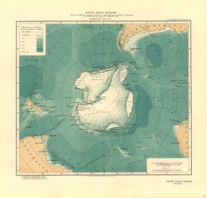
Map 3692: South Polar Regions with the Antarctic Continent drawn to illustrate the probable topography as deduced from present available data by D. Mawson, D.Sc. B.E.
Map details
| Map Number | 3692 |
| Title | South Polar Regions with the Antarctic Continent drawn to illustrate the probable topography as deduced from present available data by D. Mawson, D.Sc. B.E. |
| Edition | - |
| Scale | 1 : 40 000 000 |
| Publication date | 1911 |
| Publisher |
Royal Geographical Society (United Kingdom)
|
| Spatial coverage |
(-180.0000° -20.0000°)
,
(180.0000° -20.0000°)
,
(180.0000° -90.0000°)
(-180.0000° -90.0000°) |
| Projection | Not Given |
| Physical size | 33 x 37 cm |
| Notes |
Shows the ship's route and landings contemplated by the AAE. Scanned images (provided by the National Archives of Australia) of this map show Mawson's annotations. Map 1 annotation: "The solid line indicates the first cruise of the "Aurora" landing parties on the Antarctic continent and returning. The broken line indicates the course during the winter of 1912 when making an oceanographic survey" Map 2 annotation: "Ship's track leaving Sydney 1st Nov. 1911 - Melbourne 10th Nov. - Hobart 15th Nov - return to Perth 1st April 1912" Map 3 annotation: "Showing the ship's oceanographic survey programme during the winter and summer of 1912 between the time of landing the parties on the Antarctic continent and picking them up again". |
| Reference | 1027 |
| Keywords | South Polar Regions , D. Mawson , Historical |
Downloads
Map Lists
This map belongs to the following lists. Use the link on the list to see all maps belonging to that list
Additional Information
Preview