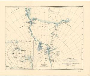
Map 3694: Routes of Captain R. Amundsen's South Polar Expedition 1911-12
Map details
| Map Number | 3694 |
| Title | Routes of Captain R. Amundsen's South Polar Expedition 1911-12 |
| Edition | - |
| Scale | 1 : 6 000 000 |
| Publication date | 1913 |
| Publisher |
Royal Geographical Society (United Kingdom)
|
| Spatial coverage |
( -90.0000° -74.0000°)
,
(140.0000° -74.0000°)
,
(140.0000° -90.0000°)
( -90.0000° -90.0000°) |
| Projection | - |
| Physical size | 36.5 x 56 cm |
| Notes | Equidistant zenithal projection. Inset : Track of the "Fram" (1:80,000,000) |
| Reference | 1071 |
| Keywords | South Polar Expedition 1911-12 , R. Amundsen , South Pole , King Haakon Vii Plateau , Queen Maud's Range , "Fram" , Ship Tracks , Historical |
Downloads
No downloads available.
This is a hard copy map. See information about obtaining copies of hard copy maps.
Map Lists
This map belongs to the following lists. Use the link on the list to see all maps belonging to that list
Additional Information
Preview