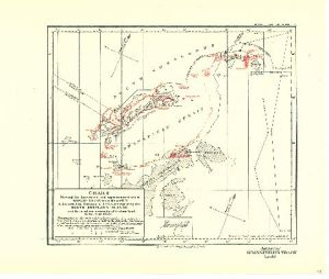
Map 3701: Chart showing the discoveries and approximate track of Edward Bransfield, Master R.N. in the hired brig "Williams" of Blyth, when exploring the South Shetland Islands and the northern extremity of Graham Land in the year 1820.
Map details
| Map Number | 3701 |
| Title | Chart showing the discoveries and approximate track of Edward Bransfield, Master R.N. in the hired brig "Williams" of Blyth, when exploring the South Shetland Islands and the northern extremity of Graham Land in the year 1820. |
| Edition | - |
| Scale | 1 : 2 650 000 |
| Publication date | March 1925 |
| Publisher |
Royal Geographical Society (United Kingdom)
|
| Spatial coverage |
( -63.1667° -60.5000°)
,
( -52.0000° -60.5000°)
,
( -52.0000° -65.0000°)
( -63.1667° -65.0000°) |
| Projection | Not Given |
| Physical size | 25.5 x 38.5 cm |
| Notes | Drawn by Lieut. Commander R.T. Gould, R.N. The coastline shown in red, has been copied in facsimile from Bransfield's chart, as published in 1822, by the Admiralty. The lettering in red has been transcribed from the original MS, chart. The remainder of the chart is based upon the most recent surveys. |
| Reference | 1183 |
| Keywords | Edward Bransfield , South Shetland Islands , Bransfield Strait , Trinity Peninsula , Ross Island , Ship Tracks , Historical |
Downloads
No downloads available.
This is a hard copy map. See information about obtaining copies of hard copy maps.
Map Lists
This map belongs to the following lists. Use the link on the list to see all maps belonging to that list
Additional Information
Preview