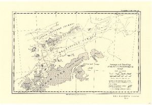
Map 3704: Surveys and Soundings of the R.R.S. Discovery II 1929-30
Map details
| Map Number | 3704 |
| Title | Surveys and Soundings of the R.R.S. Discovery II 1929-30 |
| Edition | - |
| Scale | 1 : 2 250 000 |
| Publication date | March 1932 |
| Publisher |
Royal Geographical Society (United Kingdom)
|
| Spatial coverage |
( -65.0000° -61.1667°)
,
( -51.0000° -61.1667°)
,
( -51.0000° -65.0000°)
( -65.0000° -65.0000°) |
| Projection | Not Given |
| Physical size | 24.5 x 36.3 cm |
| Reference | 1252 |
| Keywords | R.R.S. "Discovery Ii" , Trinity Peninsula , Palmer Archipelago , Erebus And Terror Gulf , Joinville Island , James Ross Island , Ship Tracks , Historical |
Downloads
No downloads available.
This is a hard copy map. See information about obtaining copies of hard copy maps.
Map Lists
This map belongs to the following lists. Use the link on the list to see all maps belonging to that list
Additional Information
Preview