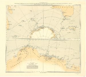
Map 3705: Charts showing the Explorations and Surveys of the British, Australian and New Zealand Antarctic Research Expedition from 1929 to 1931 under the command of Sir Douglas Mawson, O.B.E., D.Sc.
Map details
| Map Number | 3705 |
| Title | Charts showing the Explorations and Surveys of the British, Australian and New Zealand Antarctic Research Expedition from 1929 to 1931 under the command of Sir Douglas Mawson, O.B.E., D.Sc. |
| Edition | - |
| Scale | 1 : 3 000 000 |
| Publication date | August 1932 |
| Publisher |
Royal Geographical Society (United Kingdom)
|
| Spatial coverage |
(-180.0000° -10.0000°)
,
( 12.0000° -10.0000°)
,
( 12.0000° -84.0000°)
(-180.0000° -84.0000°) |
| Projection | Not Given |
| Physical size | 44 x 61 cm |
| Notes | This chart is from sketch surveys made by the B.A.N.Z.A.R. Expedition during the seasons 1929-30 and 1930-31, adjusted by frequent astronomical observations taken on board the "Discovery" and at Scullin Monolith. 2 maps on 1 sheet: 1:30,000,000 and 1:3,000,000 |
| Reference | 1253 |
| Keywords | British , Australian And New Zealand Antarctic Research Expedition 1929-1931 , B.A.N.Z.A.R.E. , Douglas Mawson , Ship Tracks , Historical |
Downloads
Map Lists
This map belongs to the following lists. Use the link on the list to see all maps belonging to that list
Additional Information
Preview