Map 3710: Graham Land as known 1934-37 (4 maps)
Map details
| Map Number | 3710 |
| Title | Graham Land as known 1934-37 (4 maps) |
| Edition | - |
| Scale | 1 : 12 000 000 |
| Publication date | 1938 |
| Publisher |
Royal Geographical Society (United Kingdom)
|
| Spatial coverage |
( -80.0000° -62.5000°)
,
( -50.0000° -62.5000°)
,
( -50.0000° -73.0000°)
( -80.0000° -73.0000°) |
| Projection | Not Given |
| Physical size | 24.5 x 36.5 cm |
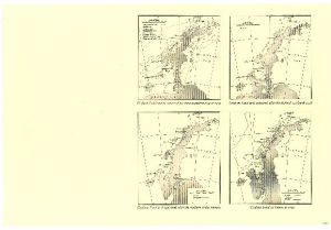
| Notes | 1. Graham Land and the routes of previous expeditions up to 1934. 2.Graham Land as it appeared after the flight of 13 March 1936. 3. Graham Land as it appeared after the southern sledge journey. 4. Graham Land as known in 1937. |
| Reference | 1333 |
| Keywords | Ship Tracks , Historical |
Downloads
No downloads available.
This is a hard copy map. See information about obtaining copies of hard copy maps.
Map Lists
This map belongs to the following lists. Use the link on the list to see all maps belonging to that list
Additional Information
Preview