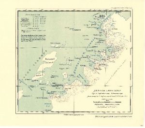
Map 3713: Graham Land Coast : B.G.L.E. September 1935 - February 1936
Map details
| Map Number | 3713 |
| Title | Graham Land Coast : B.G.L.E. September 1935 - February 1936 |
| Edition | - |
| Scale | 1 : 750 000 |
| Publication date | April 1938 |
| Publisher |
Royal Geographical Society (United Kingdom)
|
| Spatial coverage |
( -66.9167° -64.0000°)
,
( -63.1667° -64.0000°)
,
( -63.1667° -66.8333°)
( -66.9167° -66.8333°) |
| Projection | Not Given |
| Physical size | 24.6 x 33.3 cm |
| Notes | From surveys by A. Stephenson and Lieut. R.E.D. Ryder R.N. |
| Reference | 1336 |
| Keywords | British Graham Land Expedition , Biscoe Islands , Grandidier Channel , Mt. Peary , Historical |
Downloads
No downloads available.
This is a hard copy map. See information about obtaining copies of hard copy maps.
Map Lists
This map belongs to the following lists. Use the link on the list to see all maps belonging to that list
Additional Information
Preview