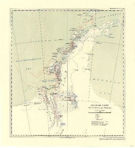
Map 3714: Graham Land : British Graham Land Expedition, January 1935 - March 1937
Map details
| Map Number | 3714 |
| Title | Graham Land : British Graham Land Expedition, January 1935 - March 1937 |
| Edition | - |
| Scale | 1 : 3 500 000 |
| Publication date | May 1938 |
| Publisher |
Royal Geographical Society (United Kingdom)
|
| Spatial coverage |
( -80.0000° -62.5478°)
,
( -50.0000° -62.5478°)
,
( -50.0000° -72.8662°)
( -80.0000° -72.8662°) |
| Projection | Not Given |
| Physical size | 38.5 x 35.3 cm |
| Reference | 1337 |
| Alternative title | Graham Land : B.G.L.E. January 1935 - March 1937 |
| Keywords | Graham Land , British Graham Land Expedition , Marguerite Bay , Charcot Island , Trinity Peninsula , Bransfield Strait. Adelaide Island , Anvers Island , Ship Tracks , Historical |
Downloads
No downloads available.
This is a hard copy map. See information about obtaining copies of hard copy maps.
Map Lists
This map belongs to the following lists. Use the link on the list to see all maps belonging to that list
Additional Information
Preview