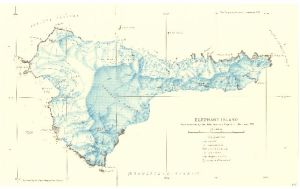
Map 3722: Elephant Island : From a survey by the Joint Services Expedition, December 1970.
Map details
| Map Number | 3722 |
| Title | Elephant Island : From a survey by the Joint Services Expedition, December 1970. |
| Edition | - |
| Scale | 1 : 132 000 |
| Publication date | September 1972 |
| Publisher |
Royal Geographical Society (United Kingdom)
|
| Spatial coverage |
( -55.5539° -61.0413°)
,
( -54.5597° -61.0413°)
,
( -54.5597° -61.3083°)
( -55.5539° -61.3083°) |
| Projection | Not Given |
| Physical size | 24.8 x 40.5 cm |
| Reference | 1455 |
| Keywords | Elephant Island , Sealers Passage , Prince Charles Strait , Sultan Glacier , Endurance Glacier , Pardo Ridge , Survey Marks |
Downloads
No downloads available.
This is a hard copy map. See information about obtaining copies of hard copy maps.
Map Lists
This map belongs to the following lists. Use the link on the list to see all maps belonging to that list
Additional Information
Preview