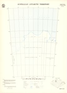
Map 447: Australian Antarctic Territory Sheet 42W [King Leopold and Queen Astrid Coast]
Map details
| Map Number | 447 |
| Title | Australian Antarctic Territory Sheet 42W [King Leopold and Queen Astrid Coast] |
| Edition | 1 |
| Scale | 1 : 2 000 000 |
| Publication date | July 1958 |
| Publisher |
Department of National Development, Division of National Mapping (Australia)
|
| Spatial coverage |
( 80.0000° -64.0000°)
,
( 90.0000° -64.0000°)
,
( 90.0000° -70.0000°)
( 80.0000° -70.0000°) |
| Projection | Polyconic |
| Physical size | 45.5 x 33.5 cm |
| Notes |
Shows West Ice Shelf. 1:2,000,000 series Additional copy of map held in folder of Phil Law Box located in Special Collections, AAD Library. |
| Reference | Sheet 42W |
| Keywords | 42W , Pydz Bay , Gaussberg , Philippi Glacier , West Ice Shelf , Posadowsky Bay , Topographic |
Downloads
This is a hard copy map that has been scanned. See information about obtaining copies of hard copy maps.
- Index for Sheet 42W (Geographical names and coordinates) (PDF)
- A print file (PDF)
- A LZW compressed TIFF
Map Lists
No maps lists available.
Additional Information
Preview