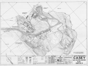
Map 5146: Casey Old Station Master Plan Issue No. 12
Map details
| Map Number | 5146 |
| Title | Casey Old Station Master Plan Issue No. 12 |
| Edition | 12 |
| Previous edition | [Previous edition : 11] |
| Scale | Not Entered |
| Publication date | September 1992 |
| Publisher |
Australian Construction Services (Australia)
|
| Spatial coverage |
(110.5317° -66.2767°)
,
(110.5428° -66.2767°)
,
(110.5428° -66.2806°)
(110.5317° -66.2806°) |
| Projection | Universal Transverse Mercator |
| Physical size | 92 x 120 cm |
| Notes | The dimensions of the plan are unknown. It is reproduced at a variety of scales. Hard copies of this plan and earlier issues are held by the Asset Management section of the Australian Antarctic Division |
| Reference | V85/465-1/12 |
| Keywords | Antarctic Rebuilding Program , site plan , master , old station |
Downloads
This is a hard copy map that has been scanned. See information about obtaining copies of hard copy maps.
Map Lists
This map belongs to the following lists. Use the link on the list to see all maps belonging to that list
Additional Information
Preview