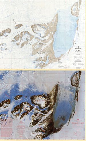
Map 57: Beaver Lake, Mac.Robertson Land
Map details
| Map Number | 57 |
| Title | Beaver Lake, Mac.Robertson Land |
| Edition | 1 |
| Scale | 1 : 100 000 |
| Publication date | 1990 |
| Publisher | - |
| Spatial coverage |
( 66.7300° -70.2983°)
,
( 69.0433° -70.2983°)
,
( 69.0433° -70.9350°)
( 66.7300° -70.9350°) |
| Projection | Universal Transverse Mercator |
| Physical size | 70 x 86.5 cm |
| Notes | This map was published as a double sided map. One side is a satellite image map and the other is a topographic map. Separate download files are available. |
| Reference | Cat.No:L13 in ANARE Catalogue - 1997 |
| Keywords | MacRobertson , Prince , Charles , Mountains , Nemesis , Amery , Murray , Mckenzie , Martin , Sandilands , White , Massif , Charybdis , Loewe , Mckinnon , Manning , Grainger , Valley , Mcleod , Butterworth , Thomson , Mclaren , Battye , Radok , Flagstone , Bench , Pagodroma , Gorge , Ritchie , Jetty , Soyuz , Else Platform , Satellite Imagery |
Downloads
This is a hard copy map that has been scanned. See information about obtaining copies of hard copy maps.
- A zipped image (TIF) of the topographic map for use in Oziexplorer
- A print file of the topographic map (PDF)
- A print file of the satellite image map (PDF)
- A zipped image (TIF) of the satellite image map for use in Oziexplorer'
- Satellite Image Map (LZW compressed TIFF)
- Topographic Map (LZW compressed TIFF)
Map Lists
This map belongs to the following lists. Use the link on the list to see all maps belonging to that list
- ANARE Catalogue of Maps and Hydrographic Charts 1997
- Beaver Lake
- Satellite image maps
- Oziexplorer maps
Additional Information
| Horizontal datum | WGS84 |
| Vertical unit | Metres |
| Magnetic variation | 69.9 degrees west in 1990 |
| Nomenclature | Australian Antarctic Gazetteer |
Preview