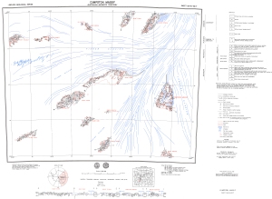
Map 934: Cumpston Massif
Map details
| Map Number | 934 |
| Title | Cumpston Massif |
| Edition | Preliminary |
| Scale | 1 : 250 000 |
| Publication date | 1975 |
| Publisher |
Bureau of Mineral Resources, Geology and Geophysics, Department of National Development, Canberra (Australia)
|
| Spatial coverage |
( 63.0000° -73.0000°)
,
( 67.5000° -73.0000°)
,
( 67.5000° -74.0000°)
( 63.0000° -74.0000°) |
| Projection | Universal Transverse Mercator |
| Physical size | 75 x 101 cm |
| Notes | 1:250,000 geological series. Compiled by R.J. Tingey |
| Reference | SS 40-42/7 (M43) |
| Keywords | Cumpston Massif , Fisher Glacier , Geysen Glacier , Mellor Glacier , Lambert Glacier , Mount Ruker , Mount Bird , Mount Newton , Mount Maguire , Mount Stinear , Mount Rymill , Mount Dummett , Mount Mccauley , Mount Seddon , Ss 40-42/7 , M43 , Geology |
Downloads
This is a hard copy map that has been scanned. See information about obtaining copies of hard copy maps.
- Image from scan (PDF)
- National Library of Australia Bib ID 4560444 (External site)
- A LZW compressed TIFF
Map Lists
This map belongs to the following lists. Use the link on the list to see all maps belonging to that list
Additional Information
| Nomenclature | Antarctic Names Committee of Australia |
Preview