NMOS88 station information
Station identification
- Primary name
- NMOS88
Locality
Red Island
View place name details in the gazetteer
Type
NGCP Control - Station 40613
This station is part of the Geoscience Australia National Geodetic Data Base - you will have to renavigate to the station page.
General
- Date last visited
-
No visits or not recorded (if present then see metadata record)
- Date last maintained
- Location details
| Coordinates |
| Datum | Latitude | Longitude | Accuracy (m) | Order | Grid | Easting | Northing | Date released | Status |
| ITRF2000 |
-52° 57' 53.743900"
-52.96492886 |
73° 18' 13.500300"
73.30375008 |
0.33 |
|
43 |
386076.370 |
4130284.500 |
1-Sep-2001 |
Current |
| WGS84 |
-52° 57' 53.870600"
-52.96496406 |
73° 18' 13.376300"
73.30371564 |
|
4 |
43 |
386074.150 |
4130280.530 |
|
Superseded |
| WGS84 |
-52° 57' 53.870600"
-52.96496406 |
73° 18' 13.376300"
73.30371564 |
|
4 |
43 |
386074.150 |
4130280.530 |
|
Current |
|
Orthometric
Heights |
| Datum | Height (m) | Accuracy (m) | Order | Date released | Status |
| |
94 |
|
4 |
|
Current |
|
| Documents |
| Type | Name/Photo/Sketch thumbnail |
| Photo Identification |
View image
|
| Photo Identification |
View image
|
| Photo Identification |
View image
|
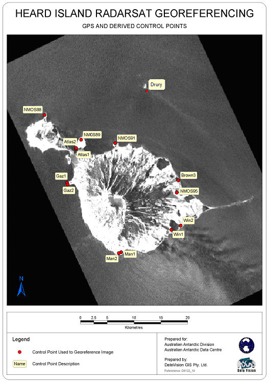
| Satellite Image |
Satellite Image Catalogue - Image Id 1977 not in the Satellite Image Catalogue.
Pixel on image - X=1044.351 (residual -0.985) Y=-2041.46 (residual 0.052)
|
| Satellite Image |
Satellite Image Catalogue - Image Id 1978 not in the Satellite Image Catalogue.
Pixel on image - X=1044.351 (residual -0.985) Y=-2041.46 (residual 0.052)
|
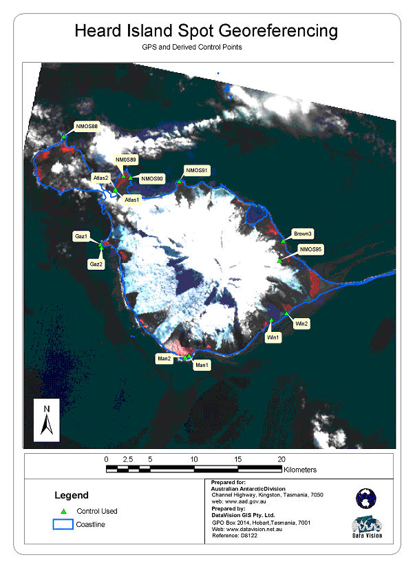
| Satellite Image |
No Image Available
Satellite Image Catalogue - View Reference 
Pixel on image - X=301.3455 (residual -0.2795) Y=481.6619 (residual -0.7131)
|
| Satellite Image |
No Image Available
Satellite Image Catalogue - View Reference
Pixel on image - X=1497.7543 (residual -0.6207) Y=240.9372 (residual -0.1878)
|
| Station Summary |
View image
|
|
There are no nearby stations within 0.25 degrees of this station.