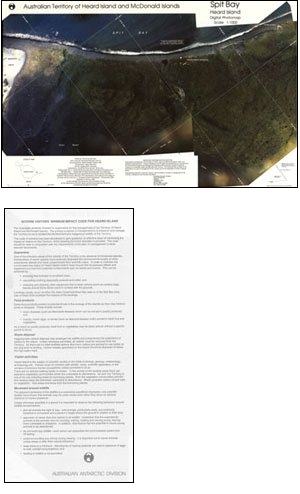
Map 12: Spit Bay, Heard Island
Map details
| Map Number | 12 |
| Title | Spit Bay, Heard Island |
| Edition | 1 |
| Scale | 1 : 1000 |
| Publication date | February 1993 |
| Publisher |
Australian Antarctic Division (Australia)
|
| Spatial coverage |
( 73.7125° -53.1042°)
,
( 73.7236° -53.1042°)
,
( 73.7236° -53.1097°)
( 73.7125° -53.1097°) |
| Projection | Transverse Mercator |
| Physical size | 47 x 73 cm |
| Notes | Digital photomap |
| Reference | L4 |
| Keywords | Spit Bay , Dovers Moraine , Stephenson Lagoon , Satellite Imagery |
Downloads
This is a hard copy map that has been scanned. See information about obtaining copies of hard copy maps.
- Digital photomap (PDF)
- Information on reverse side of map (PDF)
- National Library of Australia Bib ID 2623427 (External site)
- Digital photomap (LZW compressed TIFF)
Map Lists
This map belongs to the following lists. Use the link on the list to see all maps belonging to that list
Additional Information
| Horizontal datum | WGS84 |
| Vertical datum | Mean sea level |
| Vertical unit | Metres |
Preview