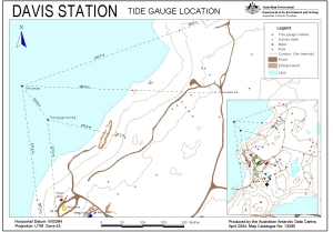
Australian Antarctic Division Conditions of Use | Feedback & requests | About us | Site map
Forgot Your Password?
Username:  
Password:
Australian Antarctic Data Centre

SCAR Map Catalogue

Map Reference

A catalogue of Antarctic region maps produced by Scientific Committee on Antarctic Research (SCAR) member countries.

Davis Station Tide Gauge Location

For definitions of the following items, consult the Map Catalogue - Definition of terms used

This is a digital map available in one or more formats (e.g. PDF, GIF, EPS). See the Links section below to obtain a copy for viewing/printing.

Title Davis Station Tide Gauge Location
Edition : 2 (Out of Date) [Previous edition] [Next Edition]
Map extent
Small map extents will be shown as a cross.
Polar map of the extents of the map
Map No. 13065
Scale 1 : 2800
Publication Date Apr-2004
Publisher Australian Antarctic Division Australia (country details)
Type Thematic Map - Superseded
Data Layers
Stations/Refuge/Depot
Survey Marks
Topography

Spatial Coverage
68° 34' 12.0" S to 68° 34' 52.0" S | - 68.5700° to - 68.5811°
77° 57' 15.0" E to 77° 59' 00.0" E | 77.9542° to 77.9833°
Projection Universal Transverse Mercator
Preview
To obtain the PDF file of this map, click on this preview or use the links below it.
(You will be required to be logged in via the Data Centre portal to obtain the PDF - Anyone can create an account.)

Dimensions 29.7 x 21 cm A4
Links
  1. An A4 print file (PDF)      Size 148.59 KB's - Required to be logged in via the Data Centre portal
Keywords Tide gauge
Additional Information
Horizontal Datum WGS84
Vertical DatumMean sea level
Links to other resources

Back to the SCAR Map Catalogue Search Page | Custodial Login | Geographic Data Home Page