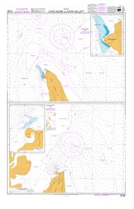
Map 13404: Cape Adare and Cape Hallett : Cape Hallett
Map details
| Map Number | 13404 |
| Title | Cape Adare and Cape Hallett : Cape Hallett |
| Edition | 2 |
| Scale | 1 : 50 000 |
| Publication date | August 2006 |
| Publisher |
Land Information New Zealand (New Zealand)
|
| Spatial coverage |
(169.8417° -72.1528°)
,
(170.7528° -72.1528°)
,
(170.7528° -72.3667°)
(169.8417° -72.3667°) |
| Projection | Mercator |
| Physical size | 49.5 x 64 cm |
| Notes |
Inset: Seabee Hook (1:15,000) See also Mapcat ref. 13479 Cape Adare published on same sheet. First ed. Jan 2003 |
| Reference | INT 9006 NZ 14906 |
| Keywords | Cape Hallett , Moubray Bay , ASPA 106 , Seabee Hook , Willett Cove , Cape Christie , Hallett Peninsula , Quarterdeck Ridge , Int 9006 , Nz 14906 , Nautical , Chart |
Downloads
Map Lists
This map belongs to the following lists. Use the link on the list to see all maps belonging to that list
Additional Information
Preview