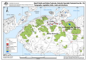
Map 13512: North-east Bailey Peninsula, Antarctic Specially Protected Area No. 135 : Topography, vegetation, birds, roads and structures (Map B)
Map details
| Map Number | 13512 |
| Title | North-east Bailey Peninsula, Antarctic Specially Protected Area No. 135 : Topography, vegetation, birds, roads and structures (Map B) |
| Edition | 2 (Out of Date) |
| Previous edition | [Previous edition : 1] |
| Next Edition | [Next Edition : 3] |
| Scale | 1 : 12 000 |
| Publication date | March 2008 |
| Publisher |
Australian Antarctic Division (Australia)
|
| Spatial coverage |
(-180.0000° 90.0000°)
,
(180.0000° 90.0000°)
,
(180.0000° -90.0000°)
(-180.0000° -90.0000°) |
| Projection | Universal Transverse Mercator |
| Physical size | - |
| Keywords | North-East Bailey Peninsula ASPA 135 , Shirley Island , Mcmullin Island |
Downloads
This is a digital map available for downloading.
Map Lists
No maps lists available.
Additional Information
| Horizontal datum | WGS84 |
| Nomenclature | Australian Antarctic Gazetteer |
Preview