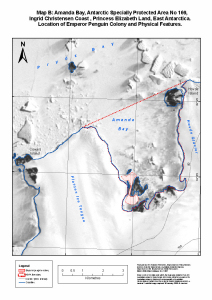
Map 13517: Map B : Amanda Bay, Antarctic Specially Protected Area No. 169 Ingrid Christensen Coast, Princess Elizabeth Land, East Antarctica. Location of Emperor Penguin Colony and Physical Features.
Map details
| Map Number | 13517 |
| Title | Map B : Amanda Bay, Antarctic Specially Protected Area No. 169 Ingrid Christensen Coast, Princess Elizabeth Land, East Antarctica. Location of Emperor Penguin Colony and Physical Features. |
| Edition | 1 (Out of Date) |
| Next Edition | [Next Edition : 2] |
| Scale | 1 : 50 000 |
| Publication date | March 2008 |
| Publisher |
Australian Antarctic Division (Australia)
|
| Spatial coverage |
( 76.6833° -69.2083°)
,
( 76.9167° -69.2083°)
,
( 76.9167° -69.3000°)
( 76.6833° -69.3000°) |
| Projection | Universal Transverse Mercator |
| Physical size | 29.7 x 21 cm A4 |
| Notes | This map is included in the management plan for Antarctic Specially Protected Area No. 169, published in 2008, which is available from the Secretariat of the Antarctic Treaty website. |
| Keywords | - |
Downloads
This is a digital map available for downloading.
Map Lists
No maps lists available.
Additional Information
| Horizontal datum | WGS84 |
Preview