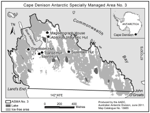
Map 13955: Cape Denison Antarctic Specially Managed Area No. 3
Map details
| Map Number | 13955 |
| Title | Cape Denison Antarctic Specially Managed Area No. 3 |
| Edition | 1 (Out of Date) |
| Next Edition | [Next Edition : 2] |
| Scale | 1 : 20 000 |
| Publication date | June 2011 |
| Publisher | - |
| Spatial coverage |
(142.6506° -67.0031°)
,
(142.6939° -67.0031°)
,
(142.6939° -67.0139°)
(142.6506° -67.0139°) |
| Projection | Universal Transverse Mercator |
| Physical size | 7.5 x 10 cm |
| Notes | Map produced for 'Visitor site guide for Mawson's Huts and Cape Denison, East Antarctica'. |
| Keywords | Commonwealth Bay , Hut |
Downloads
This is a digital map available for downloading.
Map Lists
No maps lists available.
Additional Information
| Horizontal datum | WGS84 |
Preview