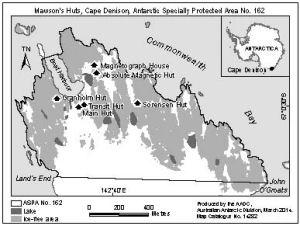
Map 14282: Cape Denison Antarctic Specially Protected Area No. 162
Map details
| Map Number | 14282 |
| Title | Cape Denison Antarctic Specially Protected Area No. 162 |
| Edition | 2 |
| Previous edition | [Previous edition : 1] |
| Scale | 1 : 20 000 |
| Publication date | March 2014 |
| Publisher |
Australian Antarctic Division (Australia)
|
| Spatial coverage |
(142.6506° -67.0031°)
,
(142.6939° -67.0031°)
,
(142.6939° -67.0139°)
(142.6506° -67.0139°) |
| Projection | Universal Transverse Mercator |
| Physical size | 7.5 x 10 cm |
| Notes | Map produced for 'Visitor site guide for Mawson's Huts and Cape Denison, East Antarctica'. |
| Keywords | Commonwealth Bay , Hut |
Downloads
This is a digital map available for downloading.
Map Lists
This map belongs to the following lists. Use the link on the list to see all maps belonging to that list
Additional Information
| Horizontal datum | WGS84 |
Preview