Map 13996: Mount Menzies
Map details
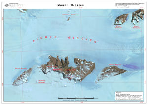
| Map Number | 13996 |
| Title | Mount Menzies |
| Edition | 1 |
| Scale | 1 : 200 000 |
| Publication date | October 2011 |
| Publisher | - |
| Spatial coverage |
( 60.7433° -73.1341°)
,
( 63.2028° -73.1341°)
,
( 63.2028° -73.5982°)
( 60.7433° -73.5982°) |
| Projection | Universal Transverse Mercator |
| Physical size | - |
| Notes | Map produced for field work associated with Australian Antarctic Science Project 2355 lead by Dr Mark Stevens of the South Australian Museum |
| Keywords | Mt Menzies , Satellite Imagery |
Downloads
This is a digital map available for downloading.
Map Lists
This map belongs to the following lists. Use the link on the list to see all maps belonging to that list
Additional Information
| Horizontal datum | WGS84 |
| Nomenclature | Australian Antarctic Names Gazetteer |
Preview