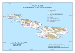
Map 14128: Frazier Islands
Southern Giant Petrel Colonies Surveyed December 2011
Map details
| Map Number | 14128 |
| Title | Frazier Islands Southern Giant Petrel Colonies Surveyed December 2011 |
| Edition | 1 |
| Scale | 1 : 9000 |
| Publication date | September 2012 |
| Publisher |
Australian Antarctic Division (Australia)
|
| Spatial coverage |
(110.1442° -66.2206°)
,
(110.1997° -66.2206°)
,
(110.1997° -66.2361°)
(110.1442° -66.2361°) |
| Projection | Universal Transverse Mercator |
| Physical size | 21 x 29.7 cm A4 |
| Keywords | - |
Downloads
This is a digital map available for downloading.
Map Lists
This map belongs to the following lists. Use the link on the list to see all maps belonging to that list
Additional Information
| Horizontal datum | WGS84 |
| Nomenclature | Australian Antarctic Gazetteer |
Preview